|
|
|
On our way to Drotsky's Cave
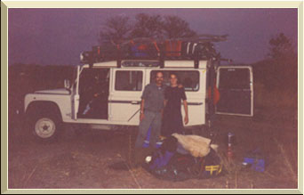
Saturday morning the 26th of June 1999 at 02:00 we left our hometown Roodepoort. A three week holiday that will take us through Botswana to Namibia and back. My two sons were very excited, needless to say, so was I.
The Land Rover was packed as we head for Naboomspruit on the Pietersburg highway (N1). We were supposed to take the off-ramp to Naboomspruit but somehow I passed it and discovered to late, as the lights of Potgietersrus on the horison start to light up the early morning sky. My targeted border post was Groblersbrug and I've planned to reach it via Ellisras and if I had taken the turn-off for Naboomspruit, we would have been at the border at 08:00!
As I am custom to the area, I did not plan properly and once we took the turn-off to Potgietersrus, I've turned back on the old road towards Naboomspruit. If I had read the map then, I would have noticed that I could have taken the N11, 172 km to Groblersbrug! The 66 km detour was fine.
We've reached Ellisras at 08:00 just in time to see how the towns traffic officer setting up his speed trap! We filled the tank of the Land Rover at a nearby garage and glanced at the road map from the AA to see how far the right hand turn towards Groblersbrug border post was from Ellisras. There was several turn-offs for Swartwater but none for Groblersbrug or Martin's Drift and slowly the road turned to the south-western direction, not the direction I was interested though! But soon a road sign said that the Stockpoort border post was around the next turn.
We were not the only people that missed the Groblersbrug turn-off but as one lady have said, "Maybe it is a blessing, because it is much easier to cross the border at small posts than bigger ones like Groblersbrug" Yes, it was easy, and they, the Botswana people even excepted ZAR currency for the road tax!
After the border crossing we had breakfast, about 10 km from the border. It was time to pull out the map to plan our new route to Serowe. The 1998 AA Botswana road map showed some road building activities towards Mahalapye and so it was but without any road signs indicating which way is Mahalapye! It took some guess work but eventually we've reached Mahalapye, a small village. We turned right on the tar road towards Palapye.
The countryside was dull as Hugo mentioned, it was flat savanna with very few trees. At Palapye we were back on the planned route and we had the wind up front. The Land Rover is not one off the most aerodynamic designed vehicle on the road and with a strong wind at your front, going forward is slow! We managed to reach Serowe just before closing time (12:45) and bought some fresh meat and other supplies from the local Spar. After a dusty shopping spree, the target was for our first camp at Xhumaga or at the Scouts camp at the Makgadikgadi Pans.
The tar road ended at Rakops and the gravel road was terrible corrugated there after and we arrived well after nightfall at the small village of Xhumaga. Road signs for the Scout camp were very confusing and after asking a local for direction we found the two spoor road through the dry river bed that led us to the camp site. We set up camp and by 23:00 we were in Never Never Land.
The next morning we were greeted by the wardens, just to remind us of the camping fees. We said that we will visit the office on our way out. It cost me 150 Pulas (1 Pula = R1-30) for the three of us. No hot shower but a clean camp site. That's where I decided not to camp at "official" camp sites anymore. I did not budget for that type of money, only for a bit of food and for fuel!
My next planned camp site was a Drotsky's Cave and we were speeding for Maun. We've reached Maun at 13:00, filled the diesel tanks and took the road to Tsau via Sehithwa.
Prior to our trip I've bought Veronica Roodt's Road Map of Botswana. She added some GPS coordinates to it and I've entered those for Drotsky's Cave into my Gamin 45 XL. If it was not for those first coordinates for Drotsky, I would have passed the two spoor road! No road sign was visible either but about 50 meters from the tar road on the two spoor road to Drotsky a battered road sign confirmed that we were on the right road. But then the speed came to a very slow 25 km/h! The road was very sandy but firm and it was the "rocking" that made it difficult to gain speed above 30 km/hour.
The sun was setting fast and I was afraid that we will not make the campsite at Drotsky in time for dinner as two "No Entrance" signs greeted us. I must add that the road is a small two spoor but about 30 meters either side it has been clean cut to act as an fire breaker. Beyond the no entry signs the road carries on in the same fashion but there seemed to be a even smaller two spoor road to the right. I said to the boys that Veronica does not mention this and we headed straight on. The road and clean cut areas next to it came to a sudden end, about 5 km from the no entry signs. At the end of the road was a road camp and a friendly Boesman came to the Land Rover to inform us that we should have taken the turn to the right at the no entry signs! He asked for some twak and I gave him a cigarette for his service and made the U-turn. At the no entry signs the sun was about to say good bye and I stopped to make dinner.
The GPS was not happy about the direction we were heading for and at a unmarked road crossing I decided to take the advice of the GPS and turned left. Not very far from the crossing we found another camp. It was some researches and upon my question if we were still on the right road he man said that there is a short cut towards Drotsky, about 1 km from the camp. Once again the people of Africa has no knowledge how far something is or how long it will take even those who do have motor car. It was about 5.5 km from his camp we we were greeted by a sign indicating that we were in a some sort of nature reserve and no hunting was allowed and a small arrow on the sign showed the direction towards Drotsky. Only later I've discovered that we were indeed on the Veronica Roodt's road towards Aha Hills but there were no indication of this turn-off. The GPS also indicated that the turn-off towards Drotsky is straight on and not to the left at the sign. I've changed the coordinates for those of the cave itself and only then the GPS was happy about the new heading.
It was already late and I was not prepared to pay 150 Pulas for a short nights camp and decided to pull off into the bush, roll out my sleeping bag next to the Land Rover while the two boys setting up their sleeping bags inside the Land Rover and went to sleep underneath a bright starlit sky. That was our second night in Botswana.
After a hot cup of coffee and Kellogg's, we pulled back in to the spoor heading for Drotsky. Although the road was sandy, traveling on it was not a problem. Then some rocky hills made their appearances and the spoor took us through a very narrow gorge and soon we were at the signboard of Drotsky cave.
We've parked the Landy underneath an old Camelthorn tree and armed with flashlights we entered the cave. The guide book did mentioned that there are to entrances and that you can enter at one and exit at the other but I forgot at which entrance you should enter first! After a long travel on bouncing spoor, it did not really mater to us which entrance to enter!
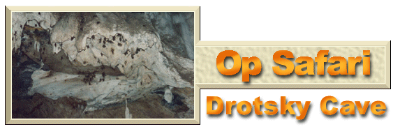
The cave itself is wonderful, the stalactite and mite are mostly unspoiled but the bed of the cave is covered with very fine Kalahari dust and deeper in the cave it's covered with droppings of very tiny bats!
Previous and current visitors maintain a string that you can follow as your guide into the cave, but I've discovered that you can not really get lost. As we followed the string it led us to a dead end, and what about the possibility to enter and exit at two different places? Well, as we've discovered later, by reentering the cave at the other entrance that you can indeed enter and exit at two different places. The two entrances are connected at a place where you have to crawl through, top of the dead end!
It was dusty and we were covered in fine red dust and as it was about 13:00 and the sun was heating our solar water bags, we took a shower while the gas stove was heating our lunch. I though about to camp at Drotsky but as it took so long to reach Drotsky we decided to head for Tsodilo Hills instead.
So we took the official or charted mapped road towards AHA Hills and passed the small village of XaiXai at sunset. We were on the lookout for a camping spot but the bush next to the road were very dense and then a well traveled road appeared on our right and we followed it, hopefully there will be a place to camp next to it.
At the end of the road we saw the welcome sight of a campfire but soon it turned to an unwelcome sight. It was the camping sight of a private safari operator, the local chief, according to him, gave him permission to entertain his guests there and we were not welcome. I assured him that we will not interfere with him or his two guests but the look on his face was to get lost and we did indeed. His accent was German and I tough about the so called hospitality of the Europeans and decided to forget about them.
So back to the "main" road and a few kilo's further we found another road to the right, followed it for a few meters and pulled into the bush, setup camp, cleaned an area for a campfire. Pieter and I slept outside on our stretchers while Hugo decided to sleep in the Landy. We were exhausted and were in Never Never Land quickly.