|
|
|
Itinerary - Introduction
- Kunene Trail - Desert
Trail - Etosha
- Preparations - Namibia
Home
Sesfontein to Swakopmund ( 660 km )
Sesfontein to Twyfelfontein ( 191 km)
After breakfast at the Fort and refilling the Landrover, we turned left into the main road towards Palmwag (Route 3706 on the Namibia Tourist map). This is not a very scenic road but we passed several camping sites along the road. There were two turn-offs on our way, where a sign warned not to enter without a valid permit. At Palmwag, a grumpy lodge worker informed us that we could have used the permit we bought at the "Courtesy Stop" before Sesfontein. Well unfortunatly, those turn-offs were a great distance back, so we went ahead through the cattle fence gate towards Twyfelfontein. One of the turn-offs were for the "Wondergat", an enormouse sinkhole affording impressive and rather daunting views into the subterranean world.
The good gravel road is wide and very white. This is a main road and takes one closer to the general tourist area of Namibia. The turn-off to Twyfelfontein is well sign posted and close to the turn-off on the banks of the Aba Huab River is a pleasant rest camp.
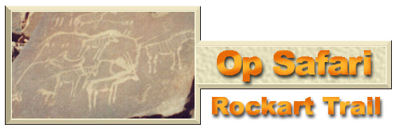
The main attraction at Twyfelfontein is its large gallery of rock engraving art which is one of the most extensive in Africa. Most of the work probably dates back to the Early Stone Age, making them at least 6000 years old,
and is probably the work of Bushmen. Although animal tracks and geometric designs are both presented in the various phases, there are very few human figures. Twyfelfontein is a declared national monument. Entrance fee is charged as well as a parking fee for your vehicle. We were not allowed to wander around on our own, but paid a guide to take us through. It was worth the fee, but parking fee?
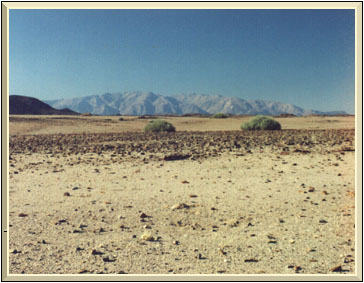
Just south-east of Twyfelfontein is the barren 12 km long volcanic ridge known as the Verbrande Berg or Burnt Mountain, which appears to have been literally exposed to fire.
The afternoon was rapidly passing while I searched for a short cut track from Twyfelfontein to the Brandberg, which I had taken 20 years ago on a visit to the same area.
At that time I travelled in a normal sedan car and did the "short-cut" without any problems. We passed by a narrow track marked "4x4 only" which I could not possibly have done in a sedan.
The map that I had also did not give any evidence of a route from the Burnt Mountain to Brandberg. We thus turned back and followed Route 2612 to Uis.
By the time we reached the turn-off to the famous 'White Lady' rock painting, it was already 17:00. As the museum closes at 17:00, we decided to give it a miss. Then Pieter read in the Guide book about the Messum Crater. The boys wanted to see the crater and it was on our way to Henties Bay.
A problem that I have encountered regarding directions by a guide book is that it explains how to find a certain point from the main route. In the dessert and anywhere off-road, rivers are seldom signposted.Thus we followed "...the 4WD track leading west along the Messum River..." not knowing which river we were following. In a situation like this, GPS co-ordinates are important. Only months after our visit to this region did I manage to find the co-ordinates for the turn-off!
The road ended at a T-junction in a gorge and we assumed that this was it. The road sign pointed right to Brandberg West and left to Henties Bay. We took the right turn, passed an old tin mine and after traveling for 14 km, stopped at the gate of 'Save the Rhino Foundation Camp'. Our guide book never mentioned this camp site, so I gathered that we did not follow the Messum River after all. As the sun was setting, we decided to stay the night.
The sign at the entrance gate gave a very clear break down of the costs and the service charges. I was really most impressed that local people were charged lower rates than foreigners and as South Africans are considered locals, I paid happily. I also committed myself to support this worthy cause. Oh, by the way, they sell ICE!
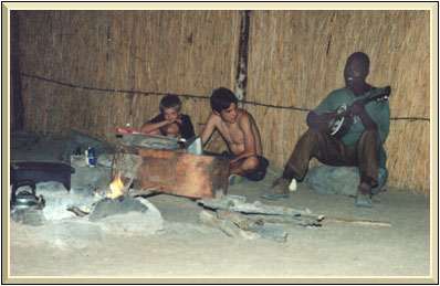
Each camp site was well protected from wind as the camp was laid out on the Augb River. It was not nessecary to pitch the tent as there was a shelter where we could sleep. Soon it was dark, and we started a camp fire.We were preparing dinner when Johannes, one of the camp keepers, surprised us with a visit. Playing his guitar he sang some of his own Rhino compositions and several Damaraland songs. Before he left, he promised to be our guide the next day to the Doros Crater, home of the Black Rhino.
The next morning Johannes took us through a steep gorge out of the river. While driving to the Doros Crater, Johannes told me that there was indeed a 75 km short cut from Twyfelfontein to the Rhino Camp. I also came accross a German tourist who showed me the route on a detailed map of the area, which he had purchased in Swakopmund. We did a detour of just over 300 km on the main route the previous day.
As it took us the best part of the morning to drive out to Doros Crater we had no time to explore and without any information or map we decided to turn around, drop Johannes off and head for Swakopmund. Needless to say, we did not spot any Rhino but saw 23 Gemsbok, 19 Ostrich and several Springbok.
We arrived just after 23:00 and headed straight for the Municipal Camp in Swakopmund. There are no camp sites, that is at Myl 4, but very nice affordable huts with hot showers and very comfortable beds. The next day we visited the town and my search for the map proved unsuccessful.
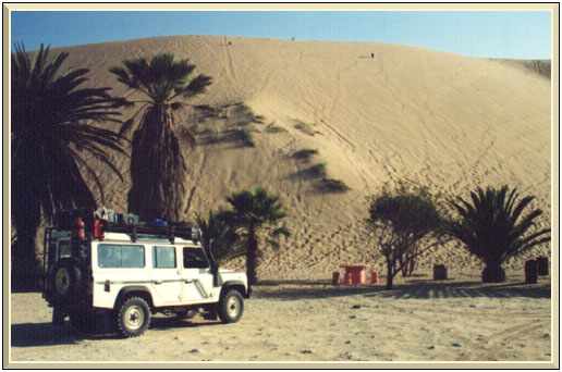
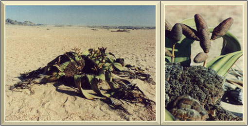
We drove to Walvis Bay, visited Dune 7 and late afternoon the boys enjoyed a 4x4 bike trail in the Swakopmund River while I fixed the nagging alternator problem, only to find a loose connection!The Welwitchia plant.
Our Namibia adventure is nearly over, but we did managed to visit the Swakopmund basin (moon Valley) and Welwitchia vlakte on our way to Windhoek via Gamsberg pass, which reaches an altitude of 2334 meters at the top. The western side of the pass is at places very steep and normally requires a downshift into 1st gear on the way up or down. The best view is from Windhoek to Swakopmund and caravans are not allowed due to the steep angle of the pass.
We arrived around 21:00 at the front door of Kentucky FC, ordered our dinner, visited the petrol station and turned the Landrover towards Gobabis, were we hoped to overnight before crossing the border to Botswana.
But 4km before the international airport, the Landrover's timing belt broke and I had to wait till the next morning to be towed back to Windhoek for repairs.
Eventually we left Windhoek at 17:00 and slept next to the road in Botswana and arrived at Roodepoort the following day at 23:00.
It was a great adventure.