|
|
|
Itinerary - Introduction
- Kunene Trail II - Desert
Trail - Rockart Trail
- Ethosha - Preparations
Namibia Home
PART 1:
Ruacana, Swartbooisdrif, Otjimbapa, Epupa.My trip to the Kaokoland and Damaraland, started at the Okaukuejo camp in Etosha and ended in Swakopmund.
The Kaokoland is a place well known to those who seek adventure. Its very name is synonymous with broken leaf-springs, rugged lonely scenery and wonderfully nostalgic memories of wild camping locations. Some wise person once wrote that "great journeys are not memorable for what you saw but for where you camped" This is especially true of the Kaokoland because here, more than in any other place in southern Africa, there is the opportunity to travel in lonely scenery inhabited by big game and yet still have the freedom to camp wherever the heart desires.
The few rough tracks that thread the valleys and plains are not for the fainthearted - especially the ones that ascend and descend steep slopes or mountain passes. Often, under a burning sun, backbreaking repairs have to be made to wash-aways that bar the route ahead. The rewards for travelling alone in this area are that you camp in splendid isolation amidst a vast wilderness of gravel plains, deep valleys and towering mountains.
My trail into the Kaokoland along the Kunene River, started after the bridge at Hippo Pools, 11 km from Ruacana. Hippo Pools, is a river fronted communal campsite located 100 m after the bridge where the tar road ends. We wanted to wet our feet for the first time in the Kunene and after paying N$15-00 at the gate, the warden aloud us 15 minutes to do so! I would advise you to rather camp there for the night and start the trail early the next morning. The sites are clean and there are long drop toilets. An entrance fee is charged. The distance from Hippo Pools to Epupa varies in different publications but I would rate Jan Joubert's 4x4 Practical Guide as the most accurate of them all, stating the distance as 148 km.
One needs a sound 4x4 vehicle to be able to visit this rugged terrain but the beauty of this trail is that one can camp anywhere. The desire to go anywhere interesting which does not require one to pass through a gate and be handed a leaflet which reads which reads: "Game Reserve - you may not do this, you may not do that, stay in your car, you may not camp outside the designated campsites" - and so on! The only restrictions are on land close to Himba settlements where one should seek permission before setting up camp.
It is also imperative to the long term success and survival of the trail that one chooses one's campsite within easy access of the main track without having to make new tracks over virgin bush to reach the ideal spot. Also don't set up camp too close to the river as cattle and donkeys often use the riverbeds as thoroughfares. Ask permission to draw water from springs and water holes. As I've not come across any Himba who understood either Afrikaans or English, I kept clear of the settlements.
From Hippo Pools to Swartbooisdrif ( +2 hours drive) it's 56 km over tough steep track. For the first time I had a sound vehicle, unlike the two Landrovers I owned previously. One was over 25 years old and the other was a bastard, a mixture of several other vehicle parts which could not properly perform.
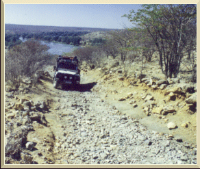
The first "tricky" track was ahead of me with boulders on a steep and narrow mountain track. We had to pull in the side steps of the Landrover as the side of the track was occasionally very high and could tear off the side steps. I was a bit nervous when the front wheels started to grip on these huge stones. We were alone and if something unfortunate should happen to us we would be stuck as help was far away. I switched on the Gear Max diff lock on the back wheels, switched into low range and away we went. I made a short prayer, and the boys must have done as well because we went through the pass easily. I was under the impression that the diff lock on the back wheels did work, but after cleaning the Landrover back home, discovered a loose connection! Just before Swartboois -drif, you will find Kunene Lodge where you can camp although a fee is charged. There are also several basic bungalows. Kunene Lodge is mainly used by Safari operators and the lodge also caters for Canoe Safaris on the Kunene River. The Lodge is fenced.
At Swartbooisdrif there is a connection road to the left to Ehomba. There use to be a Lodge with camping facilities at Swartbooisdrif but it was very much deserted with no visible activities noticed. Passing the turn-off to left, one comes past the grave of a Himba Headman. Be respectful while visiting the grave site as the Himbas regards these burial sites as holy sites. This grave was fenced and the headstone was covered with a pink cloth, why, I have not managed to find the answer yet.
From Swartbooisdrif to Otjimbapa (60 km) the track runs along very rocky and stoney terrain.
This is probably the most difficult part of the trail. Just after the Headman's grave there is a Catholic Mission and Clinic on the right. You will also pass new military type tents. First I thought that the area were invaded by the military and that we would run into trouble, but soon discovered that these tents were supplied by the military for setting up tented schools in the Kaokoland. There are several tribes among the Himba and you will pass some of them. Some tribes do some planting and you will find agricultural land along the Kunene.
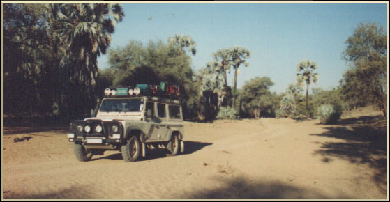
The last part of the 60 km you travel underneath Makalani Palms, Camel thorn, Lead wood, Tamarisk and Ana trees on soft riverbed sand. Due to flood damage to the roads and especially going through ditches and small dry streams, alternative tracks were formed to make driving easier. There are several of these, as I call them, detours.
Drive carefully and slow, especially over the rocky passes.
I've come across rocks with hit marks caused by sumps and thereafter a tell-tale trail of sump oil. This could spell a disastrous trip, far away from the nearest town for help.
At the turn-off towards Omuramba at Otjimbapa there were some confusion as to which track to take. I wanted to follow the river towards Epupa but found myself on the Omuramba road. The golden rule here is to keep right. At the time of my trip, I only had a few GPS coordinates, and did not have the coordinates for this junction.
From Otjimbapa to Epupa ( 33 km) the track once again is difficult and the last part of it is very rocky. The other track from Swartbooisdrif to Epupa is 93 km and will take 8 to 10 hours to complete.
Otjimbapa to Omuramba ( 37 km), an alternative route, is fairly easy as most of this route is over flat land through Mopane bushes until you reach a river crossing. By now, one expects to find detours around difficult obstacles, as was the case at the river crossing.
The river is quite wide. The tracks were fairly deep and it was filled with some surface water. On the other side of the river the trail went up a fairly steep gradient and over two small sand humps. These sand humps however was enough to get one stuck. I elected to take the "detour" track a few meters back. This track follows the river and goes through a Himba settlement until it reaches the river edge. Unfortuately that's where the track ended as there were two steep sand humps to negotiate and no indication in the river bed of any tracks that crossed it! Jan Joubert does mention false route in his book.
We turned back to the original river crossing and walked across to inspect the firmness of the wet sand. It was not too difficult as we started the decent into the river in low range first gear. The Landrover took us willingly through the loose, water logged sand and over the sand humps on the other side. We noticed that several previous travelers used wood and Makalani Palm leaves to rescue them from the loose sand.
After the river crossing one carries straight on. There is a wind mill on the right and tracks that leading towards it. Keep straight on, the track goes through a small river and then passes a fairly big kraal, named Omuramba Kraal, where the track eventually reaches a T-junction. Turn right into the fairly well used gravel road. This is the main road from Okangwati to Epupa.
Okangwati to Epupa (31 km)

With the spotlights on top of the roof we had a good view of the road condition.Some parts of it was badly corrugated. We could manage a speed of 60 km/h but had to hit the brakes as the road narrowed descending into a steep and stoney gorge. About 10 km before Epupa you will find an airstrip on your left and a Headman's grave, well visited by tourists, on your right before you enter the valley descending towards Epupa. As the road makes a turn towards the right, close to the river, there is a well organized camp site, directly to your left. There are flush toilets and cold water showers. This camp is maintained by the local Himba community. A camp fee is charged and you will be visited by the caretaker. The campsites are underneath Makalani Palms on the waterfront and very clean. Next to the "Tourist Camp" is another private camp with camping sites and further on, two Safari Lodges.One can buy freshly baked bread from the Himbas. All camps are fenced to keep to prevent live- stock wandering through the tents. Petty theft has been reported, so keep valuables well hidden or locked away in your vehicle. There are plans to set up a Kiosk just outside the camps where art and handmade items can be bought.
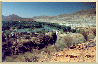
It's well worth spending two or more days at Epupa falls to explore up and down stream. This is a wonderful place to relax and to appreciate prolific bird life.