|
|
|
Itinerary - Introduction
- Kunene Trail I - Desert
Trail - Rockart Trail
- Etosha - Preparations
Namibia Home
PART 2:
Omuramba, Okangwati, Otjitanda, Otjihende, Van Zyl's Pass, Marienfluss, Otjinungwa.Epupa via Omuramba & Okangwati to Otjitanda (133 km)
Departing from Epupa early morning, I back tracked my route passing Omuramba towards Okangwati. This road is in a fair condition but as you near the Omuhonga Mountains it's a rocky road.After the Mountains there is a Himba traditional kraal on the left, 12 km before Okangwati. Arriving at Okangwati you turn right into the village, passing a sign that says "Van Zyl's Pass". It's not a traditional village, more like a disorganized modern African village but you will pass an old fenced military base on the left as you leave the village. Go through a dry river bed and on the other side keep left in a south-westerly direction. The road close to the village is well maintained by the local Himba. The first part of the track is occasionally sandy and rocky and passes by a concrete dam, 18 km from Okangwati on the left. After 27 km you will come across the grave of a Himba headman. 57 km From Okangwati you will pass Ovivero Dam on the right. Otjitanda is still 6 km further on.
Otjitanda to Van Zyl's Pass ( 36 km)
Turning right after the village, the route heads west over the beautifully dramatic and treacherously steep rocky terrain. Once again in 4x4 country, as you leave Otjitanda the road drops into a riverbed and follows a narrow gorge between two granite koppies. Once through the gorge the road opens into a beautiful Acacia-Mopane woodland which serves as an ideal camping site. Then the road becomes extremely difficult and very rocky as one approaches the look-out point at Van Zyl's Pass.
Van Zyl's Pass to Otjinungwa Camp at the Kunene ( 65 km)
It is on this part of the trail that you will be confronted by scenically spectacular and challenging Van Zyl's Pass which opens onto the Marienfluss. Taking the road to the right on the summit one reches the look-out. This short detour is well rewarded by the bird's eye view of the Otjinjange Valley below. The upper part of this valley is known as the Marienfluss.
The 3 km downhill is very steep but the track is in good condition. The pass drops to an altitude of some 550m from a height of 1323m at the peak. The last approximately 500 meter was a hair raising experience. Although the track is in good condition, there were a great amount of small pebbles which made the road slippery against the steep gradient. Take special care at the penultimate 90 degree bend, as the road declines toward the outer edge. If not negotiated with great care one could easily over turn the vehicle and roll down the mountain side. This is the main reason for descending rather than ascending the pass.
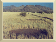
Once in the Marienfluss the track is in good condition as you drive westwards in the fairly narrow valley. When the valley broadens, the road becomes more corrugated up to the Y-junction, the Marienfluss Junction. To the left is the road to Rooidrom, but head straight on for 41 km towards Otjinungwa Camp. A feature of the Marienfluss is the circular patches of bare, sterile ground in the grass, also referred to as Fairy Circles. These patches vary in size from two to five meters in diameter.
There are several signs indicating the whereabouts of the camping site. There is a private Safari camp as well as a communal camp with long drop toilets. Beautiful Ana trees line the river but be aware of the crocodiles in the Kunene. You may visit the nearby rapids downstream, approximately 5 km from the camp.I traveled from Epupa Falls to Otjinungwa Camp in one day; arrived at the summit of Van Zyl's Pass at sunset and late night at the camping site. I would advise that the distance be done over two days as one misses much of the scenery along the route during night time driving. I would rather camp en route after Otjitanda in the woodlands.
My Kunene Trail ends at Otjinungwa Camp along the slow flowing Kunene River. From here my Desert Elephant Trail starts, which will take us through some of the best parts of Damaraland and ends at Twyfelfontein.